Road Trips and Tiny Trailers
All you need for planning the best road trips in your tiny trailer!
LANDSCAPES (Coastlines) Fun Facts
COASTLINES
DEFINITION:
According to Merriam-Webster, the definition of a ‘coastline’ is:
“1: a line that forms the boundary between the land and the ocean or a lake”
“2: the outline of a coast”
********************
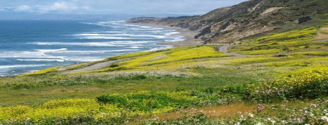
I know what I think about when I think of Coastlines: Sandy Beaches, Sun, Salt Air, Waves, Beach Volleyball at Family Reunions, Sand Crabs, Shells, Sharks, Seaweed… With everything that is great (and even not so great) about Coastlines, the beach remains one of my favorite places to be.
What’s also great about the coast is learning a little about all the different types of Coastlines that exist! This knowledge has helped me make the most of whatever I’m currently enjoying. Maybe it’ll be fun for you too!
********************
BASIC CHARACTERISTICS OF A COASTLINE:
*Coastlines are constantly changing and being sculpted and formed by waves, tides, sea levels, weather and erosion.
*Tides determine the contents of a coastline. Coastlines can be made of sand, gravel, sediment, silica and shells. The deposits that the tide brings up onto a coastline determines the color of the beach.
*A tide always returns to the ocean at a right angle to the coastline
*Canada has the world’s largest coastlines equaling 152,100 miles around.
*Nearly 40% of the world’s population live within 93 miles of a coastline.
*The long, narrow wedge of sand that has its steep slope facing the sea is called a ‘berm’.
*The wavy rolling surfaces that form in the sand in an arc pattern and called ‘cusps’.
*According to the Guinness World Records, the tallest sandcastle ever made was constructed in Connecticut in May 2011. It was 37’ 10” tall.

SOME DIFFERENT TYPES OF COASTLINES:
A). Ria Coastline:
*A Ria is a coastal formation that was once a river valley but in now flooded and open to the sea.
*Rias are formed on coastlines that were not created by glaciers.
*Rias are formed by flooding due to either the rise of the sea or the sinking of the land.
*Rias can have a branch-like appearance that looks like a tree from above or a have long, straight finger-like structure.
*Rias can go for miles stretching from the sea to the mainland.
*Rias often have many small islands within their areas.
*Rias typically have large brackish water (water that is a mix of freshwater and salt water) area.
*Rias often serve as a drainage basin for its surrounding area.
*Ria is also referred to as submergent
*Narragansett Bay is an example of a Ria coastline.
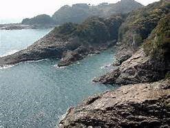
An example of a RIA Coastline is the Chesapeake Bay off the coast of Virginia
B). Fjord Coastline
*A Fjord Coastline is one where valleys created by glaciers along the coast submerge into the sea.
*Fjords are typically surrounded by high mountain cliffs and can be a deep as 4000’.
*When a glacier meets the sea it forms a fjord by receding, becoming landlocked and/or melting.
*Fjords have a mild climate and tend to remain ice-free.
*The fjords have an abundance of wildlife, mammals and fish.
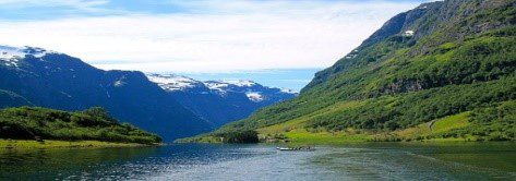
Fjord coastlines can be found off the coasts of Washington and Alaska
C). Barrier-Island Coastline
*The Barrier-Island coast is a recently emerged coastal plain. It is a low ridge of sand, lying a short distance from the coast, and is created by waves. Barriers increase in height as coastal winds fortify the island with dunes.
*Barrier-Island coastlines are full of islands and small lagoons.
*13% of the world’s coastlines are chains of barrier-islands.
*Barrier-Islands won’t form where the sea levels are unstable.
*Padre Island in south Texas is the longest barrier-island chain in the world.
*Barrier-Island chains are always in the process of moving and changing.
*The Great Barrier Reef in Australia is the largest living structure in the world and is about half the size of Texas.

Barrier Islands can be seen from New York to Texas off the Gulf and Atlantic Coasts
D). Delta Coastline
* As a river meets the sea, its flow abruptly slows down. As a result, it drops its load of sediment in a huge fan of deposits. When the deposits get to heavy for waves to carry them out to sea, a Delta forms.
*The deposits brought down by a river is mainly silt, sand and clay.
*The river tributaries divide and subdivide creating a fern or bird-like shape and are always moving.
*Deltas typically have a curved arc shaped coastline.
*Most of a Delta is underwater. The Delta Plain is what is visible above water and the Delta Front is the steep slope that faces the sea.
*Deltas have extremely fertile soil but can be hard to cultivate do to the flooding cycles. Agriculture is still done on Deltas in Northern California.
*Deltas are some of the diverse bio diverse areas on the planet and provide a habitat for many species of plants, animals and fish. They also provide safety for many endangered species of animals.
*The primary human use of a delta region is to gather sand and gravel.
*Deltas also act as barriers to reduce impact from hurricanes.
*The Mississippi River Delta is the largest Delta in the U.S. It is about 2,359 miles long and moves about 200 feet per year.
*The Ganges-Brahmaputra Delta in India is the world’s largest Delta at 41,000 sq. miles.
*In the U.S., major Deltas can be found in the Gulf Coast, the Gulf of California and the Puget Sound in Washington State.
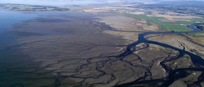
Delta coastlines found along the Gulf of Mexico
E). Volcano Coastline
*Volcano coasts arise where volcanic deposits (lava and ash) flow from active volcanoes into the ocean.
*Wave action erodes the fresh deposits, creating low cliffs.
*Beaches are typically narrow, steep, and made up of fine particles of rock.
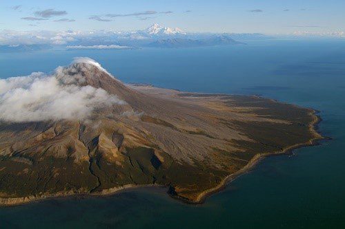
Volcano Coastlines can be found off the coasts of Washington State and the Hawaii Islands
F). Fault Coastline
*A Fault Coastline is a coastline that rests against the steep side of a Fault which is called a Fault Scarp. A Fault Scarp is the steep side of where the earth’s surface fractures or cracks heaving one side upward and the other downward.
*A Fault Coastline is always moving and shifting due to it being on the fracture or crack of the earth’s surface
*A Fault Coastline tends to be straight and sharp.
*A Fault coastline usually has tall mountains or rocks next to the shore.
*A Fault Coastline is typically rocky.
*The San Andreas Fault is the most dangerous Fault line in the U.S.
Fault Coastlines can be seen off the coasts of Alaska, Washington State and California
********************
So no matter what type of coastline you find yourself on basking in the sun, learn a little about it and impress your friends with your knowledge! It’ll give them something to make fun of you behind your back with…